COUNTY AND REGIONAL OVERVIEW
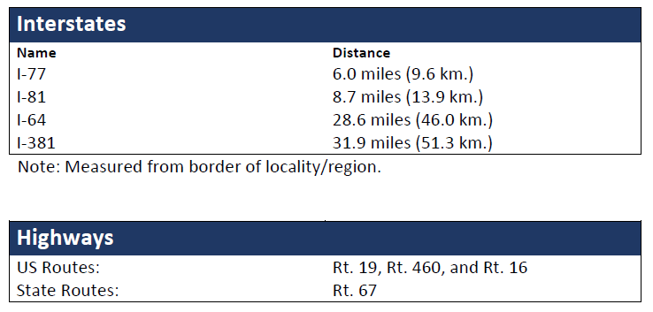
Nestled in the Appalachian Mountains of southwest Virginia, Tazewell County is a vacation and sportsman’s paradise! It is a region of beautiful green mountains, rolling hills and wide-open valleys that covers 522 square miles. The county’s accessibility to Interstates 77, 81, and 64 make it a convenient location for all markets east of the Mississippi and in the Midwest USA.
Richmond, the state capital, is 281 miles northeast; Roanoke is 110 miles east; and Bristol is 70 miles southwest. The county is ideally located within the geographic center of the east coast and within one day’s drive of 47% of the nation’s population.

Population in Thousands (2018)
- Tazewell County – 40.9
- Extended Labor Market Area – 280.6
Labor Force Participation (2013 – 2017)
- Tazewell County 49.8%
- Extended Labor Market Area 47.9%
Civilian Labor Force (2019)
Unemployment Rate
(May 2023)
- Tazewell County 3.6%
- Extended Labor Market Area 5.7%
- Statewide 2.9%
Educational Attainment
- On-Time Graduation 88.9%
- High School Graduates (25+ Years Old) 79.7%
- Bachelors Degree or Above (25+ Years Old) 15.2%
Tazewell County Unemployment Rates
(2016 – 2018)
%
2016
%
2017
%
2018


